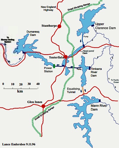
The Clarence River Scheme, as proposed by the late Professor Lance Endersbee, and other water diversions in this north-east New South Wales catchment cannot be delayed any longer. In February there was flooding on the Pacific Highway at South Grafton, and heavy rainfall across the region led to the closure of several roads. Flooding left both ferries at Ulmarra and Lawrence out of service. But now seven months later the largest reservoir in the area,
Lake Copeton, is only at 16.3 per cent of full capacity. This would not be the case if the Clarence catchment floodwaters were made available in an inter-basin transfer. Lake Copeton is one of the largest inland reservoirs in NSW with a capacity of 1,364 gigalitres (GL), nearly three times that of Sydney Harbour. Such a low dam level at 16.3 per cent, as of 9 September, is very concerning for this north-east region of the Murray-Darling Basin. In addition, the Menindee Lakes along the Darling River, as of 9 September, are at only 26.6 per cent capacity and could be much higher with the benefit of floodwaters from the Clarence River catchment. Despite a high net evaporation loss of 399 gigalitres per year, the Menindee Lakes’ massive 1,731-GL capacity, combined with regular Clarence River floods would ensure they never run dry again as they did earlier this year and in 2015-16.
An exclusive report by the Guardian on 24 September 2019, headlined “NSW secretly exploring long-dismissed plan to turn coastal rivers inland”, stated that WaterNSW has looked at diverting flows from the Clarence, Manning, Macleay and Hunter rivers inland. The Guardian obtained WaterNSW documents via a freedom of information request, and reported that the inter-basin water transfer proposal put forward by WaterNSW “echoes the plan for turning rivers inland first mooted by John Bradfield, the engineer who designed the Sydney Harbour Bridge, in 1938”.
One project from the WaterNSW documents involves taking water out of the Aberfoyle River, which feeds into the Clarence River via the Guy Fawkes, Boyd, Nymboida, and Mann Rivers. Water would be transferred about 50 kilometres west via tunnel to tributaries of the Gwydir River which feeds into Lake Copeton. The proposal put forward by WaterNSW considered sending water to Rocky River, Laura Creek and Georges Creek which are all tributaries of the Gwydir River. The Guardian reported it was costed at $1.8 billion. A dam could be built on the Aberfoyle River in the Guy Fawkes River National Park, which hilly region provides a deep valley for maximum water storage and minimum evaporation. This project to divert water to the Gwydir River would complement Prof. Endersbee’s proposal which diverts water to the Dumaresq River. And since Copeton Dam lies on the Gwydir River, the benefit of this inter-basin water transfer is clear.
As expected, the Guardian attempted to ridicule the water projects as an “expensive gift to irrigators”, and under the guise of “complex” environmental concerns. Not surprising from an establishment-backed newspaper with a track record of similar bogus claims. Perhaps the Guardian’s owner, Scott Trust Limited, is directing this attack, given its dependence on income from HSBC, one of the biggest promoters of “sustainable finance”. Scott Trust board member Sir Anthony Salz was until recently Vice Chairman at Rothschild Inc., and other Scott Trust board members have close ties to the City of London financial oligarchy, the actual power behind the anti-dam campaign.
Proposals for a Clarence River Scheme to divert floodwaters into the Murray-Darling Basin are not new. In 1954 Farmer and Settler staff writer John Heney outlined such a plan in the 26 February 1954 issue of his newspaper. He notes the constantly recurring floods in the region which “are tragedies that take valuable human lives, desolate the landscape, ruin farms and break hearts”. Heney provided a six-point plan which included dams on the Tweed, Clarence and Macleay rivers fairly high up in the eastern slopes of the Dividing Range. The second point of the plan called to divert the water in these dams “through tunnels under the range and make it flow into the Darling River tributaries”.
Prof. Endersbee described his Clarence River Scheme in a speech to the Citizens Party (then Citizens Electoral Council) on 23 November 23 1997: “There is the catchment of the Clarence River and it is a wonderful little cup in there and very steep country, high rainfall and one of the highest rainfall areas in Australia, and they get the summer rains from the monsoons coming down and they get the winter rains as well. … So I have worked out, designed a scheme for the diversion of the Clarence into the Darling. Now, as you know, there are a lot of algae in the Darling…. This would flush all the algae out of the Darling.” Prof. Endersbee went on to explain how hydroelectric generation capacity will make this scheme economic. But the economic advantages don’t stop here! Flood damage in the Clarence region, costing many millions of dollars, will be mitigated in future. Billions of dollars’ worth of new agricultural products will be generated every year. And rather than wasting $3.1 billion of taxpayers’ money to purchase water, only to flush it into swamps and out to sea, the government could allocate such funds to help improve the lives of Australians for a change!
By Jeremy Beck, Australian Alert Service, 9 September 2020


