Connect with us:


Untapped rivers in northern Australia provide many agricultural export opportunities which will be crucial for any economic recovery plan to save the nation. New dams and vast irrigated areas will be an important food bowl for growing Asian markets, provided Australia adopts an integrated plan including transport infrastructure to conquer the tyranny of distance. High-speed rail and a new national port in Darwin, combined with high-speed shipping will make this possible. Just consider the potential in the Timor Sea Drainage Basin which has 20.3 per cent of the nation’s surface water, versus the Murray-Darling Basin with only 6.1 per cent. Australia’s second-largest reservoir by volume, Lake Argyle, could support an irrigated area several fold over current levels. And many other dams in this Drainage Basin would transform the region.

Lake Argyle at full supply level contains 10,700 gigalitres (GL) of water, or over 18 times the volume of water contained in Sydney Harbour! Completed in 1971, the Ord River Dam impounding Lake Argyle is yet to fulfil its original intention of creating 52,000 hectares of irrigated lands in Western Australian and a further 20,000 hectares in the Northern Territory. A much smaller diversion dam forming the 90 GL Lake Kununurra was completed in July 1963. By 1968 thirty farms covering 10,500 hectares were operating but following the construction of the Ord River Dam, progress has been painfully slow. Ord Stage 1 covering 14,000 hectares of irrigated farmland is in operation, but further stages are yet to be completed.
Around four decades ago the Snowy Mountains Hydroelectric Authority proposed a dam on the Katherine River just upstream of Katherine Gorge. The project was placed on the back burner as the anti-dam lobby captured the public mind in a coordinated media campaign opposing the Franklin River Dam. If the Katherine dam had been built Katherine would not have been devastated by the 1998 flood which saw the river rise to its highest level on record to 20.4 metres. A state of emergency was declared and nearly a quarter of the town’s residents were evacuated to centres on higher ground. Aside from flood mitigation, a Katherine River dam would provide a body of water about half the size of Lake Argyle which could support a thriving agricultural industry. In addition, controlled water releases into Katherine Gorge during the dry season would be an added benefit in providing greater access for tourists. Les MacFarlane, member for Elsey in the Northern Territory Legislative Assembly from 1974 to 1983, was a passionate advocate for a Katherine dam. Today’s politicians need to take up this fight again.
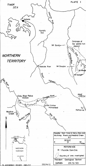
The 1963-64 Preliminary Inspection of Proposed Dam Sites by J. Barclay of the Commonwealth government’s Department of National Development considered eight potential dam sites on the Mary and Daly Rivers and the associated tributaries of the McKinlay River and Muldiva Creek. In addition, four potential dam sites were reviewed for the Douglas, Cullen and Fergusson Rivers. The proposed dam on the Douglas River, a tributary of the Daly River, at 13° 43’ 58” S 131° 35’ 12” E is located where the river flows westward through a gorge. At this point the gorge is 30 metres deep and 60 metres wide at the top, which would provide a useful water storage while minimising evaporation.
Other dam site proposals considered also included topography for maximum water storage. One possible site for a large dam on the Daly River just downstream from the Buldiva Creek junction is where the river flows through a gap in the Rock Candy Range, which the report states is “composed of Stray Creek Sandstone of Upper Proterozoic age”. The gap was noted as some 600 metres wide and 20 metres deep. Barclay’s report acknowledged the study was only preliminary and more investigation would be required. At the time in May 1963 the team made use of a helicopter to assess possible sites from the air, and made landings where possible to further assess the geology.
The Commonwealth Department of National Development which undertook the above study existed between January 1951 and December 1972. This was an optimistic time in Australia’s post-WWII history where jobs were plentiful and real living conditions were rapidly advancing as we developed the nation. The post-industrial, anti-technology counterculture which then took hold prevented any development of Australia’s north, and Lake Argyle still sits there grossly underutilised. The current economic crisis must be a wakeup call to overthrow this paradigm.
Engineering great, Professor Lance Endersbee AO long campaigned to develop Australia’s northern rivers. In 1997 he presented the Australian Ring Rail Proposal which would link irrigation districts in the north with the rest of Australia’s population; but, importantly, also to a national port in Darwin which would deliver perishable high-value crops to Asian markets in high-speed catamaran ships travelling at around 40 knots (74 km/h). It’s now beyond time for such vision.
By Jeremy Beck, Australian Alert Service, 14 October 2020