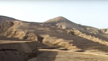
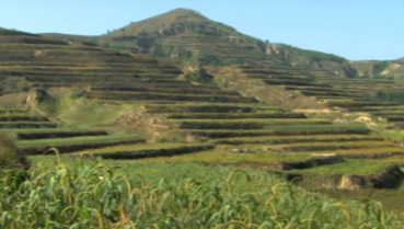
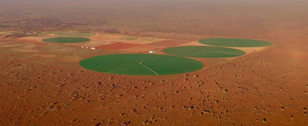
Vast land areas of planet Earth in the state of barren exhausted desert can be transformed into lush green oases. Such a transformation would expand agriculture while providing an environment for enhanced biodiversity. Real-world examples show what is possible: China’s Loess Plateau Watershed Rehabilitation Project, launched in 1994, greened an area almost the size of the Netherlands; the Central Valley Project of California, USA launched under President Franklin Roosevelt in 1933 reclaimed a desert and provides water to approximately 1.2 million hectares of irrigated agricultural land; and hundreds of hectares near Ti-Tree—190 kilometres north of Alice Springs in the Northern Territory—is home to the production of table grapes, the second largest horticultural industry in the NT.
China’s Loess Plateau Watershed Rehabilitation Project has transformed an area of over 35,000 square kilometres and increased agricultural production and incomes on 15,600 square kilometres of land in the tributary watershed of the Yellow River. The primary objective of the project was to increase agricultural production. A secondary objective to reduce sediment inflows to the Yellow River has been achieved by locating the project areas in the parts of the Basin with severe soil erosion. Millions of tonnes of silt are swept down the Yellow River, which gets its name from this soil. The barren Loess Plateau during the dry season also leads to dust storms in Chinese cities far away.
Chinese-American filmmaker John D. Liu in 1995 as a cameraman got an assignment to film the Loess Plateau. From that moment on, greening deserts became Liu’s life’s goal, as he made important discoveries in soil science. His 2008 film Lessons of the Loess Plateau showed how greening this once barren and eroded land was possible. The Loess Plateau locals terraced hillsides to prevent further erosion; livestock grazing was prohibited in some areas to allow vegetation regrowth, but government provided compensation and incentives for the locals, including land rights, so the people had ownership in the project.
The Loess Plateau project includes more than 5,340 large dams (with storage capacity over 500 megalitres) and more than 50,000 medium and small dams (under 500 megalitres) which provide water storage. The smaller dams’ primary purpose is to counteract erosion and ensure sediment retention. Such dams, known as check dams, along with restoration practices have sharply decreased suspended sediment in the Yellow River. A paper titled “Stepwise decreases of the Huanghe (Yellow River) sediment load (1950–2005): Impacts of climate change and human activities”, published in the journal Global and Planetary Change in June 2007, remarked on the sharply reduced sediment load and stated the Yellow River “seems to be reverting to the pristine levels characteristic of the middle Holocene, prior to human intervention”.
Liu’s filmmaking has been funded by the IUCN National Committee of The Netherlands, the Rockefeller Foundation and World Bank et al., and Liu and other ecologists promoting the project focus on debatable theories in ecology and the role of carbon dioxide in climate change. Nevertheless, the merit of greening barren and exhausted lands stands on its own. And besides genuine environmental benefits, thriving agricultural and economic activity on the plateau is now the reality just two decades since this the project commenced.
Central Valley Project
US President Franklin Roosevelt launched the Central Valley Project (CVP) in 1933 during the Great Depression. Extending more than 600 kilometres through central California, the CVP incorporates a multi-purpose network of dams, reservoirs, canals, hydroelectric power stations and other facilities. After some delays, construction on major CVP facilities began in 1938 with the Shasta Dam on the Sacramento River. Over the next five decades the CVP transformed the region with 20 dams and reservoirs that collectively hold around 15,000 gigalitres (GL).
Water transferred from northern California to the San Joaquin Valley and its surroundings under the CVP has transformed a desert into America’s breadbasket. Water deliveries by the CVP include providing an annual average of 6 million megalitres water for farms and 740,000 megalitres of water for municipal and industrial uses (enough water to supply about 2.5 million people for a year).
Central Australia
Soils in much of central Australia just need water and they bloom with life. We witness this following floods whose waters drain into and fill Lake Eyre on rare occasions. Several farms near Ti-Tree in the Northern Territory show what is possible. In this case, bores are used to extract groundwater. Crops in the Ti-Tree Water Control District include mangoes, table grapes, melons, and citrus. In addition, the production of fodder crops such as lucerne for cattle has replaced some of the grape and melon production which the area has been known for since table grapes were first planted in Central Australia in 1974.
The NT Government estimates the groundwater storage capacity of the Ti-Tree aquifer is 7,160 GL, with a recharge of 7.24 GL per year. But by building the Bradfield, Reid and Clarence River Schemes among other interbasin water transfers schemes, groundwater will be complemented by vast quantities of surface water which would transform inland Australia into an oasis.
By Jeremy Beck, Australian Alert Service, 14 April 2021


